
"Mar Dulce" redirects here. For the Bajofondo's album, see Mar Dulce (album).
Lake Nicaragua, from the Land I was born in! Every time I travel by car from Costa Rica to Nicaragua I have the honor to see it on my right hand... long, wide, floaded... one of the future only sweet water source... our new gold...our future!
Lake Nicaragua has the following coordinates as written in WIKIPEDIA:
"Location Nicaragua
Coordinates 11°37′N 85°21′WCoordinates: 11°37′N 85°21′W
Primary outflows San Juan River
Catchment area 23,844 km²
Basin countries Nicaragua
Surface area 8,264 km²
Max. depth 26 m
Water volume 108.00 km³
Surface elevation 32.7 m
Islands 400+ (Ometepe, Zapatera, Solentiname)
Lake Nicaragua or Cocibolca or Granada or (Spanish: Lago de Nicaragua, Lago Cocibolca, Mar Dulce, Gran Lago, Gran Lago Dulce, or Lago de Granada) is a vast freshwater lake in Nicaragua of tectonic origin. With an area of 8,264 km2 (3,191 sq mi), it is the largest lake in Central America,[1] the 19th largest lake in the world (by area) and the 9th largest in the Americas. It is slightly smaller than Lake Titicaca. With an elevation of 32.7 metres (107 ft) above sea level, the lake reaches a depth of 26 metres (85 ft). It is intermittently joined by the Tipitapa River to Lake Managua.
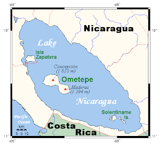
The lake drains to the Caribbean Sea via the San Juan River, historically making the lakeside city of Granada, Nicaragua, an Atlantic port although it is closer to the Pacific. The lake has a history of Caribbean pirates who assaulted nearby Granada on three occasions.[2] Despite draining into the Caribbean Sea, the Pacific Ocean is near enough to be seen from the mountains of Ometepe (an island in the lake).
Before construction of the Panama Canal, a stagecoach line owned by Cornelius Vanderbilt's Accessory Transit Company connected the lake with the Pacific across the low hills of the narrow Isthmus of Rivas. Plans were made to take advantage of this route to build an interoceanic canal, the Nicaragua Canal, but the Panama Canal was built instead. In order to quell competition with the Panama Canal, the U.S. secured all rights to a canal along this route in the Bryan-Chamorro Treaty of 1916. However, since this treaty was mutually rescinded by the United States and Nicaragua in 1970, the idea of another canal in Nicaragua still periodically resurfaces. Ecocanal is one of these projects."

This amazing lake is awaiting for your visit! Come and enjoy an evening in Granada and meet the amazing Granada Islands.
Nicaragua es a beautiful peaceful land. People are great hosts and prices are great! Our amazing fauna en flora variety will kill you. Our known and unknown history, modern vikings wanting to colonized Nicaragua around the 1920´.
Come and meet our beautiful jungle... our beautiful Caraebbe and Pacific Coast too. WE ARE WAITING FOR YOU and YOUR PROJECT! For more information write to me at sylviakgron@yahoo.es


No comments:
Post a Comment